Trip Overview
One of Nepal’s more difficult treks is the Manaslu Circuit Trek. An increasingly popular new trekking destination is the Manaslu Circuit. However, compared to the well-traveled trekking paths in the Annapurna region, it still gets fewer hikers. Additionally, hiking near Manaslu provides a rare chance to see a comparatively “unspoiled” part of Nepal. In addition to having the world’s tallest mountain range, the foothills and plains are as breathtaking. Manaslu trekking provides all of that.
Since it opened relatively recently and has been designated as a restricted area, the Manaslu region in Central Nepal receives less visitors. This is done to protect the local culture and avoid the kind of commercialization that is common in other well-known trekking destinations. The entire Manaslu massif is covered by this trek. It is also the most effective way to discover all of Nepal’s botanical and cultural diversity.
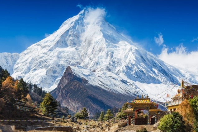
This location is made even more thrilling by the breathtaking mountain panorama of the Manaslu Himal (8163m), the eighth-highest mountain in the world, and the neighboring peaks. The journey is basically a 160-mile round route that circles multiple mountain ranges, connects diverse settlements, and follows Budi Gandaki, a clear glacier runoff river. This trek introduces the sacred mountains, amazing views, warm hospitality, and culture of the Nepalese people. Manaslu circuit trek is one of the most unforgettable trip in Nepal.
Highlights
- Enter a restricted area in the Manaslu region of Nepal.
- An ideal unusual experience for tourists who are physically fit
- Trek around Mount Manaslu, the eighth-highest mountain in the world.
- Explore the Manaslu Conservation Area’s natural treasures.
- Explore terraces, cross rivers and streams on suspension bridges, stroll through rhododendron forests, and take in stunning waterfalls.
- Spend nights in isolated mountain communities beneath a starry sky.
- Discover the inhabitants’ gracious hospitality and their distinctive way of life.
- Savor nature, breathtaking mountain views, and a variety of landscapes.
- Trekking to the Manaslu Base Camp, Birendra Lake, Pun Gyen Gompa, and the Nepal-Tibet border
- Go across the difficult Larkya La pass.
Travel insurance for the Manaslu Circuit Trek
You must purchase travel insurance that includes emergency helicopter evacuation if you plan to trek the Manaslu Circuit. There is no transportation facility in the Manaslu region. You can either walk or fly in and out of the region. Travel insurance is required for a smooth and quick rescue in an emergency.
Essential tips for trekkers
- Fitness preparation: Engage in vigorous strength training and aerobic exercises, walk for extended periods of time, and get ready for the Manaslu Circuit trek. You need to increase your endurance and stamina. Running, swimming, cycling, and day hikes are some suggested activities.
- Hiking without a guide: Manaslu Circuit trek without a guide is not allowed. This trek explores a restricted area in Nepal for foreigners. As per the restricted area travel rules, foreigners must be accompanied by a guide and travel with a Nepali-registered trekking company like us.
- Cost & additional expenses: Our Manaslu Circuit trek cost starts at USD 1,650 per person. We provide special discounts on big groups that you can see below. Do note that, apart from our Manaslu Circuit trek package cost, you will come across some additional expenses like travel insurance, tips, international flights, trekking gear, shopping, additional food and beverages, etc. Please make sure to budget accordingly.
- Do not wear new trekking boots: If you wear brand-new trekking boots in the mountains, you will get blisters. It will make trekking very difficult. So, buy your trekking boots early and get used to them.
Customize the Manaslu Circuit trek itinerary
To modify the Manaslu Circuit trek schedule, get in touch with us. Our staff will assist you in selecting the ideal expedition to fulfill your needs. You can select your desired departure date and add more services to the bundle.
Similarly, if you wish to extend the trek, combine Tsum Valley into your program. We can also combine the Manaslu Circuit trek with the Annapurna Circuit, allowing you to do two incredible circuit treks in Nepal together. Likewise, we provide a range of day activities in Kathmandu to make your trip to Nepal excellent.
Him-trail offers the best service for the Manaslu Circuit trip.
We don’t sacrifice guest safety or service quality in order to provide affordable package prices. We promise the best service and the most affordable Manaslu Circuit trip price available. You can thus reserve the Manaslu Circuit trip 2025/2026 departures with us without worrying.
Him-trail guarantees a hassle-free and fulfilling Manaslu Circuit trek thanks to their more than 12 years of experience in the Nepali travel sector. Our trips are eco-friendly and hugely support the locals because we work directly with native guides and porters.
For the best Manaslu Circuit trek experience, choose us!
Included/Excluded
- All arrival and departure transportation airport / hotel / airport.
- Three Star (Tourist Standard) hotel in Kathmandu with bed / breakfast basis.
- A guide who can speak English and government licensed.
- Food in Trekking (B-L-D).
- Lodge accommodation during trekking.
- Applicable TIMS (Trekking Information Management Systems) card.
- Manaslu restricted area permit.
- Applicable TIMS (Trekking Information Management Systems), Manaslu and Annapurna Area Conservation and Special Permit for Manaslu Area.
- Transportation by bus before and after trek with trips briefing with full information and reconfirmation of your international air tickets also.
- Welcome or Farewell dinner in Kathmandu at authentic Nepalese restaurant with cultural programs.
- Note: We strongly advise you to take out your personal travel insurance from home.
- Nepal Visa-International airfare-personal travel / medical insurance.
- Drinks items (soft & hard), personal expenses.
- Emergency evacuation by any means of transportation including Heli services and personal medical kit.
- Tips for guide and porter.
- Early return from the trip due to personal / medical problem in this case clients should bear his / her own expenses on return from trek and in Kathmandu including expenses of accompanying guide / porters.
Tour Plan
Arrival in Kathmandu (Tribhuvan International Airport). Transfer from airport on a private bus to hotel. Free evening, short pre-tour briefing before dinner.
Visits to locations with historical and religious significance, including Pashupatinath, Boudhanath & Swayambhunath (Monkey Temple), Hindu temples, old palaces (in and around Durbar Square Area), and inner-city market squares, are included in the guided tour of Kathmandu.
The bus travel from Kathmandu to Soti Khola in the Gorkha district takes ten hours. We will cross the Trishuli River en route to Dhading and Salyantar in the north. We will go on paved roads to Dhading, but the journey to Arughat will be difficult, despite the breathtaking views of Shringi and Ganesh Himals. A bit further on, we drive to Soti Khola, where we will spend the night. (Good camping spots and nearby teahouses are available.)
We hike through the stunning Sal forests after crossing the bridge, and then we ascend to a hill over the enormous rapids of the Budi Gandaki. After that, follow a trail that winds up and down before heading higher to the Gurung settlement of Lapubesi (2.5 hours). We walk openly to Nauli Khola, cross a suspension bridge, and then climb steeply for 1.5 hours to Khanibesi, where we have lunch. On the way to Machha Khola, which is located directly next to the riverbank, the rocky trail continues to climb and descend past a tall, tumbling waterfall. (Lodges are a little better than they were earlier.)
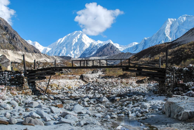
The entire day is spent strolling along the riverbank. Navigate a suspension bridge as you depart Machha Khola. On the way to Kholabesi, the rocky track crosses a stream in a rocky valley and has a few little ups and downs. More of the same until we come across three hot springs along the trail, where we may also have lunch. We take a 20-minute stroll from the hot springs to another suspension bridge that crosses Budi Gandaki. The track now heads east along the river, climbing over a ridge to Doban on a broad, well-designed stairway. (Simple lodges in the area.)
We ascend the stone stairs after traversing a suspension bridge over the Yaru Khola, descend to the river, and then ascend additional stone stairs to reach Tharo Bharyang. We hike along the river, cross the west bank of the Budi Gandaki, rise over a mountain, and then ascend to the settlement of Jagat, which also has an MCAP checkpoint. More significantly, you can refuel your energy reserves with some delicious Nepali cuisine. The views of Shringi Himal become much more prominent after a 20-minute hike. After Salleri, the trail gradually climbs, and the final stretch after the bridge wears you out with a lengthy, steep climb to Phillim, a sizable Gurung village and the MCAP office headquarters (quite excellent lodges available)
After Philim, you begin to feel as though you are in the middle of the majestic Himalayas. On this day, the trail passes through a picturesque but steep gorge that is desolate. After crossing the Budi Gandaki and descending to the grassy land slopes, you continue trekking along the west bank for a bit before crossing to the east bank and returning again. The valley gets wider as you proceed down the trail, passing through bamboo trees on your way to Deng Khola. We arrive at the small settlement of Deng after traversing the Khola. Spend the night in Deng. (There are very simple teahouses available.)
We cross the Budhi Gandaki and ascend to Rana at 1910m after a short stroll beyond Deng. To reach a trail from Bhi, keep going for an hour along the zigzag path. Ahead, the path crosses a stream, climbs on stairs past a waterfall, and then descends to another stream. You reach the Shringi Khola suspension bridge by a series of winding pathways. We pause for lunch in the village of Ghap, which is surrounded by mani walls, after crossing the bridge and continuing on a trail that rises steadily for another thirty minutes. Cross meadows and enter a dense forest that is filled with monkeys and birds and full of large firs. The path ascends beside the river. to a cascade. After crossing a wooden bridge to reach the south bank, the trail climbs steadily through the forests for a considerable amount of time before reaching Namrung (2 hours). (Very picturesque campsites in the trees to the right of the trail, as well as simple teahouses)
Witnessing the lifestyles of Nubri people, you will start the day. Exploring their Tibet-influenced typical lifestyle you will walk past several mani walls, lush terraces and houses through Banjam to enter the fir, rhododendron and oak forest. The next big village, Lihi, is reached after a steepish ascent (1.5 hrs). A unique feature of this village is the closely packed stone houses which are grouped together like apartments and share a common roof and courtyard. Beyond Lihi, cross a wooden bridge then ascend back up to another cluster of stone houses of Sho village (1 hr). Manaslu North and Naike Peak are first seen on the hike up to Lho. Manaslu (8,156m/26,760ft) is known as the mountain of the spirit from the Sanskrit Manasa, which means "intellect" or "soul." It is the eighth highest peak. The trail continues on to Shrip after crossing a small valley, and then it climbs steeply to the ridge and the sizable settlement of Lho. The monastery in the large, clustered town of Lho is home to a Lama school with 80–90 resident scholars.
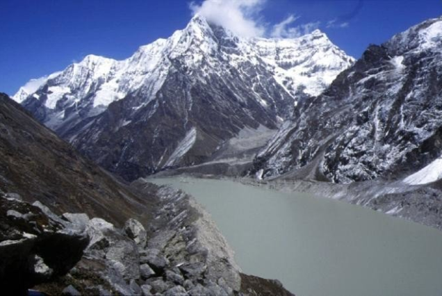
The day begins on a hard descent, passes Thusang Khola, and then gently ascends through damp forests before arriving at the settlement of Shyala (3330m, 2 hours), which has a spectacular scenery with views of Himalchuli, Peak 29, and Manaslu. A bridge across the Numla Khola, which drains the Pungyen Glacier from Manaslu, and a slope out of the stream valley that descends to a rock-strewn moraine are both crossed later on the trail. After clambering over the boulders, the trail reaches a peak with a view of Samagaon. You can eventually reach the numerous buildings and homes of Gompa by taking a leisurely stroll along a stream through the village (2 hours). The community is only five hours away from Manaslu Base Camp. We'll eat lunch in the village. (Better campsites/teahouses with a good assortment of cuisine)
A day of rest and acclimatization. You have the option of hiking to Pung-gyen Gompa or spending the day taking in Samagaon culture. An optional day trip that delves into some rich Sherpa culture is available for those who like to learn more. You may take in images of Sherpa ladies wearing traditional attire and decorations, as well as thousands of mani stones engraved with Buddhist teachings. An ancient gompa, Pungyen Gompa, is a monastery with stunning views of the glacier that may be reached by hiking up a small hill close to the Sama hamlet.
Crossing the Manaslu Glacier and continuing past a track that splits left in the direction of the Manaslu Base Camp marks the beginning of a quick and simple day's walk. After passing through a small woodland with birch, juniper, and rhododendron, the trail emerges onto a ridge. It then descends to a wooden bridge before climbing onto the headland and making a last push to Samdo. With the border only a day's walk away, Samdo is also known as a Tibetan refugee hamlet, making it easier for Tibetans to enter covertly. (Simple teahouses)
Continue down a wide path past Samdo, descending to the 3850m crossing of the greatly diminished Budi Gandaki. An ancient mani wall that signifies the beginning of the attack on Larkya La pass will soon be encountered. On the other side of the massive Larkya La glacier, the trail softly climbs through juniper and tundra. You will need to exert more effort as the trail becomes steeper after an hour of climbing up on the slope to the right on the now-obscured trail. The trail soon comes to a viewpoint at 4000m on the brink of a massive gorge. Scale to the Larkya Rest House by climbing in and out of the gorge. (Very little teahouse with little room to pitch tent).
Eat a substantial breakfast in Dharamsala because you will be embarking on a longer hike today. Despite being a more difficult trail, you will pass through several rural settlements, pristine glacial lakes, stunning valleys, a diverse array of plants and animals, and some noteworthy snow-capped summits. Start with a lengthy, slow climb next to a moraine, then cross a small ridge, descend briefly to a lake, and then continue climbing to the moraine's summit (4700m). As it traverses the moraine and leads to a ridge, the trail will become increasingly difficult and rugged. After descending to four frozen lakes, there is a final, difficult ascent to the pass at 5,100 meters (5 hours).
With the difficult days behind us, things become comparatively easier. Visit a nearby ridge for breathtaking views of Manaslu, Lamjung Himal, Himlung Himal, and Cheo Himal after breakfast in Bimthang. Continue along the trail, passing across a high grassland and then a bridge that spans the Dudh Khola River. From here, continue a trail through a small valley and through a forest of rhododendron until you arrive to Karche, the valley's highest cultivated area. Travel through verdant fields before climbing steeply over a mountain and then descending to the riverbed to reach the village of Gho, where you will be greeted by a delicious Nepali lunch. Stay on the north bank of the river and continue through fields interspersed with oak and rhododendron before entering a big Gurung settlement of Tilije.
After leaving the settlement, proceed along the river embankment till you reach a bridge over Dudh Khola. After that, the trail climbs past a mani wall to Thonje, crosses Dudh Khola once more, and descends through scrub trees into the Marsyangdi valley. Following the bridge over the Marsyangdi river comes the next settlement, Dharapani, where the Annapurna Circuit trail converges. It is not far away. (Excellent teahouses and camping areas near teahouses)
Day 17: Jagat-Besisahar (760m, 7 hrs)
A long but easy day’s walk begins with a gradual uphill (15 mins), then the trail flattens out for 20 mins before a relentless downhill to a suspension bridge over Marsyangdi river. Back again on a level-stretched trail through Marsyangdi valley before a brief climb (20 mins) approaching Bahundanda (3 hrs). After lunch at Bahundanda, the trail goes downhill again for about 1.5 hrs before easing into a flat track for the rest of the way through verdant terraced fields and colourful villages to Besisahar (4 hrs), where we spend the night partying and reveling on our achievement. (Good teahouses available)
Board a bus that is going in the direction of Kathmandu.
Transfer to airport by chartered vehicle.
Explore


Discover the soul of Nepal with Him-Trail, where each journey brings you closer to the country’s vibrant traditions and breathtaking views.
Important Links
We Are Associated to: