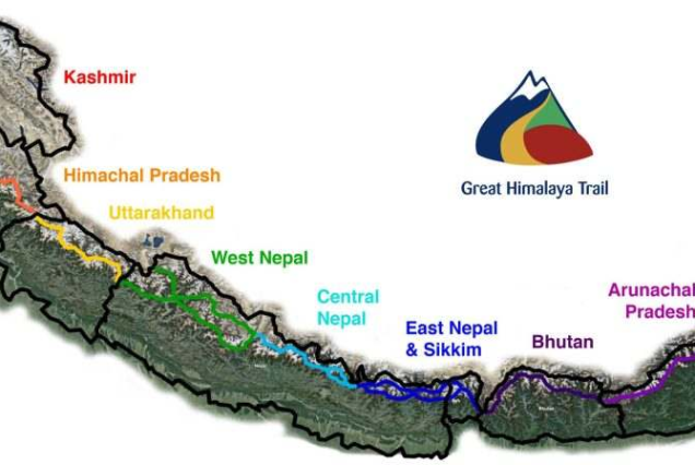
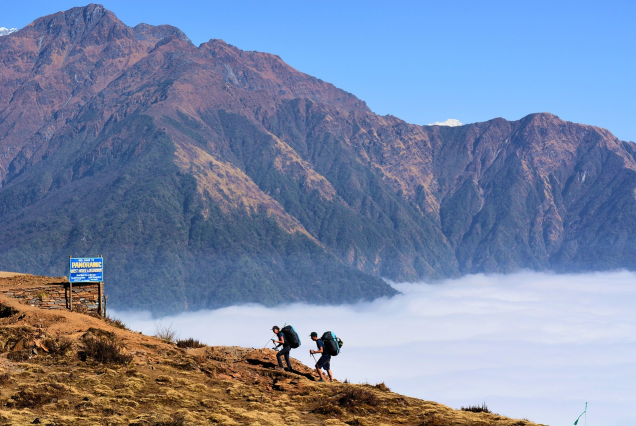
The Great Himalaya Trail designates a series of trekking paths that constitute one of the longest and highest trails globally. On the paths, there are two route choices. The elevated route stays quite near the tall summits, whereas the cultural route follows lower paths.The complete Great Himalaya Trail spans the entire range of the Himalayas, beginning in Pakistan and extending through Nepal, India, and Bhutan. In this article, we will concentrate solely on the Nepali segment of this upper trail, which spans nearly 1700 km in length.
The high route in Nepal travels from east to west, beginning north of Kanchenjunga Base Camp, passing through northern Nepal, and concluding at Hilsa, located on the Tibetan border of Humla District. You will be hiking at elevations reaching 6,146m, and the entire high-route journey will require approximately 150 days to finish. You need to be in excellent shape and completely ready with all necessary equipment, travel insurance, and climbing gear. Selecting this trek requires you to possess ice climbing skills as well.The lower path is notably shorter than the upper path, spanning approximately 1,500 km, and you will be hiking for about 100 days in Nepal’s mid-hills, reaching a highest point of 4,519 meters at the Jang La Pass. The lower path goes through various local ethnic communities and landscapes, including forests, meadows, and farmed land.
Trekking the whole Great Himalayan Trek is very difficult and intensive, so it is good to approach the trek in sections. Here are the upper trail sections of the Great Himalaya Trek.
Kanchenjunga
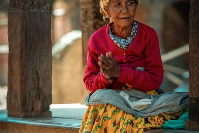
It is the eastern section of the Great Himalayan Trail in Nepal and is named for Kanchenjunga (8,586m), the third-highest mountain in the world. Mt. Kanchenjunga is situated in a conservation zone abundant with alpine meadows, untouched woods, and elevated wetlands, making it one of the sparsest populated areas in Nepal. This area houses over 2,000 types of flowering plants.To get to the Kanchenjunga Base Camp, you must start from Tumlingtar. While hiking, you will encounter welcoming Rais and Limbus villages that slowly transition into Sherpa and Tamang communities further north at elevated altitudes. Many of these ethnic groups originally relocated here from northern Tibet.
From the paths in the northwest, you can view Makalu and Everest. The majority of trekkers on the GHT (Great Himalaya Trek) begin their adventure at Jhinsang La Pass located in the Kanchenjunga area. The path continues through the Walung village, noted for its stone and wooden homes, and moves into the Makalu area.
Here are some key features of the Kanchenjunga section Trek.
- Mout Kanchenjunga (8,586m)
- Alpine woodlands, grasslands, and marshes
- Wildlife includes red pandas, Himalayan black bears, snow leopards, and Assamese macaques.
- Woodlands teeming with diverse species of rhododendrons, orchids, lilies, and various other blooms.
- Sherpa villages
- Yanglung Glacier
Makalu Barun
West of Kanchenjunga is the Makalu Barun area of the Great Himalaya Trek. The journey now continues in Makalu Barun National Park after traversing Lumbha Sambha from the Kanchenjunga area; upon entering the Everest section, you need to cross the difficult three cols (passes). This is the most challenging technical hike in Nepal, surpassed only by ascending taller peaks.
You can access the Makalu Barun area by flying into Tumlingtar (400m), and then you will proceed to Makalu Base Camp (4,755m). These trekking areas have very few inhabitants, and you will journey through numerous rhododendrons and pine woodlands to arrive at Barun Valley, home to the Makalu Base Camp.From the perspective slightly above the Makalu Base Camp, you can savor the sights of several of the highest peaks globally, such as Everest (8,848m), Lhotse (8,516m), and Makalu (8,463m).
The journey to Makalu Base Camp will take approximately ten days. Following Makalu Base Camp, traveling west, you will traverse the three passes – East Col (6,146m), West Col (6,143m), and Amphu Labsta (5,848m) – before entering the Everest area.The Barunste glacier is situated between the east and west cols, representing the toughest part of this route. The Amphu Labsta offers stunning vistas of Everest, Lhotse, and Island Peak, and upon crossing Amphu Labsta, you will arrive in the Imja Tse Valley. You will travel from the Imja Valley to Namche Bazzar, then to Lukla, from which you can take a flight back to Kathmandu.
Here are some key features of the Barun Valleys section Trek.
- Arun and Barun Valleys
- Three prominent passes – East Col (6,146m), West Col (6,143m), and Amphu Labsta (5,848m)
- 440 bird species
- 25 varieties of rhododendrons
- Red Pandas, Clouded Leopards, and Asian Golden Cats.
- Travel through five climate zones, ranging from Tropical to Alpine.
- Everest (8,848m), Lhotse (8,516m), and Makalu (8,463m) peaks
Rolwaling/Everest
The Makalu Barun portion of the Great Himalayan Trek connects with the Everest/Rolwaling segment at the three passes. Getting to this part of the Great Himalayan Trek is simpler than earlier treks. You can take a flight to Lukla from Kathmandu. You can also hike to this area starting from Jiri.
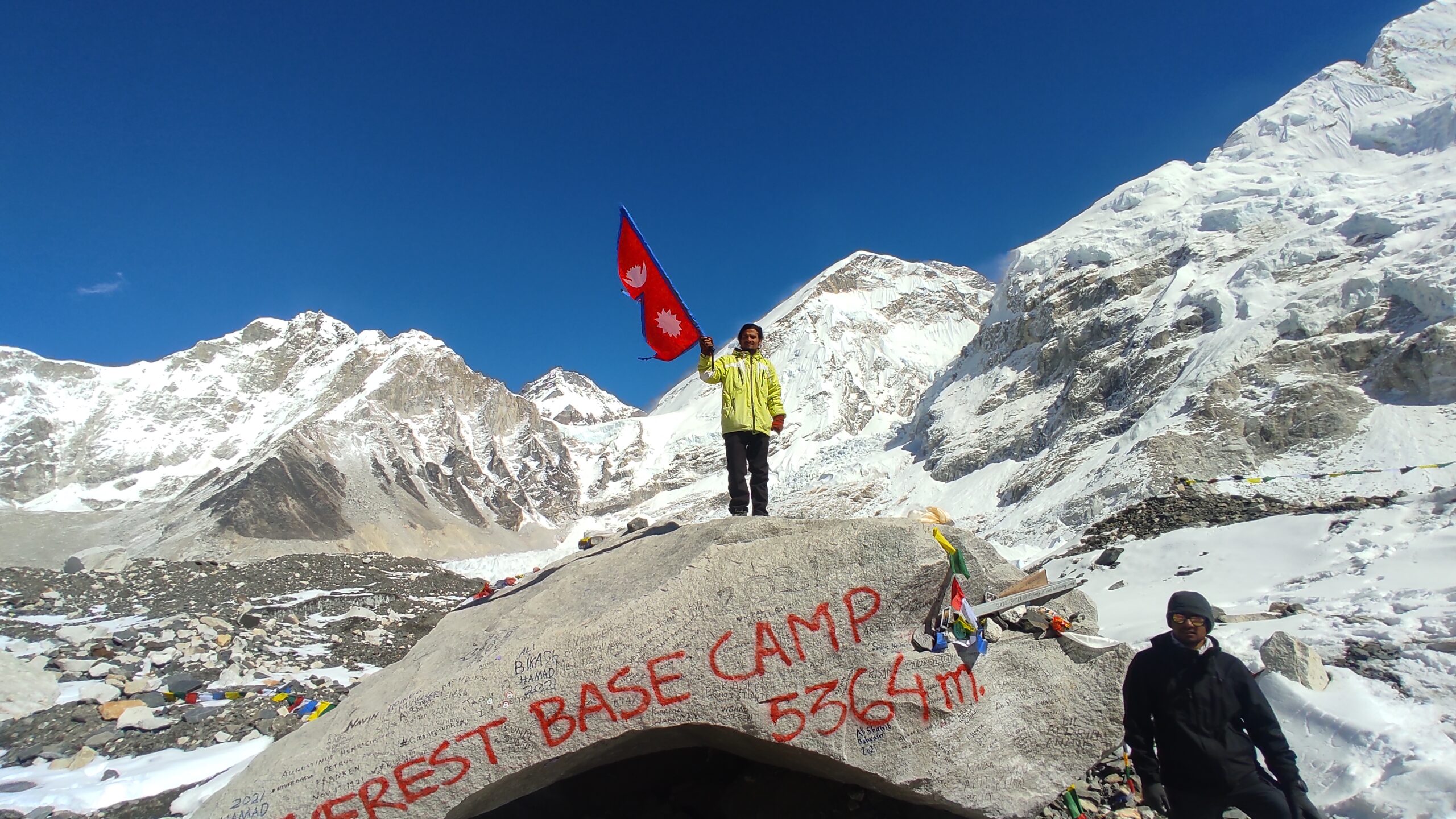
This section of the Great Himalayan Trek is likely the most famous because of the Everest Base Camp journey. Each year, thousands of adventurers/trekkers visit this area. The tourism facilities in this area grew with lodges/teahouses located in optimal spots. You will traverse multiple Sherpa villages, communities, and monasteries. Numerous trekking paths exist, but we suggest the “Three High Passes” trek.
This area offers breathtaking vistas of the tallest peaks, such as Everest, Cho Oyu, Makalu, and Lhotse. Many elevated passes and mountain lakes will make your journey exciting and rewarding.In 1952, Edmund Hillary (one of the initial climbers on Everest) and Shipton (an English alpinist) traversed the three passes and proceeded eastward in the Makalu area.
However, as you travel west from Khumbu, the Great Himalayan Trek moves into the Rolwaling Valley via Tashi Lapache (5,760m). This is a highly difficult path, which was formerly the quickest way for the Sherpas to get to Kathmandu.Upon entering the Rolwaling Valley, you will encounter the two traditional villages of Beding and Bigu Gompa. As you traverse the trails, you can take in the stunning views of Gauri Shankar. In contrast to Khumbu, Rolwaling has greater diversity with Tamangs, Sherpas, and Gurungs.
Here are some key features of the Rolwaling Valley section Trek.
- Three of the tallest mountains – Everest, Lhotse, and Cho Oyu
- Sherpa communities and way of living
- Animals that thrive in high altitudes include yaks, snow leopards, deer, and others.
- Ancient monasteries, such as Khumjung monastery, are believed to have stored yeti scalps.
- Sagarmatha National Park
- Lakes at high elevation – Gokyo
Langtang Helambu
The Everest and Rowling part of the Great Himalaya Trek connects Langtang and Helambu to the west close to Jugal Himal. This part is the simplest to access. You can easily exit Kathmandu and make your way to Helambu. Buddhists hold Helambu in high esteem, and its residents refer to themselves as Hyalmo. These inhabitants are connected to the Sherpas in the east.
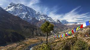
You will be hiking in Langtang National Park, where there are small hidden lakes, with Gosainkunda being well-known as a revered lake for Buddhists and Hindus. Upon traversing the Tilman Pass (5,308m), you will arrive in the Langtang area. From the pass, one can see Tibet and stunning views of glaciers and snow-capped mountains, with the most prominent being Langtang Lirung (7,227m).
Here are some key features of the Langtang Helambu Valley section Trek.
- Langtang settlement and Kyangiin Monastery
- Wide mountain vistas from Kyanjin Ri (4,773m)
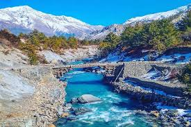
- Mountains covered in snow, cascading waterfalls, and numerous suspension bridges.
- Breathtaking sights of Langtang Lirung (7,345m), Gang Chhenpo (6,388m), Naya Kanga (5,846m), Dorje Lakpa (6,966m), Kimsung (6,781m), and Yansa Tsenji (6,575m).
- Red pandas, Snow leopards, musk deer, bears, langurs, and more.
- Incredible Lirung and Kimshung Glacier
- Ancient and important Buddhist monasteries, stupas, and structures
- Dairy plant and trek to Tserko Ri (5,450m)
- Vibrant green woods and pastures
Ganesh and Manaslu
The Great Himalaya Trek’s Langtang and Helambu part connects with the Ganesh Himal area to the west. Manaslu mountain approximately sits at the center of the Great Himalaya Trek.
To reach this part of the Great Himalayan Trek, you must travel west from Kathmandu. The majority of hikers arrive in Syabrubesi by bus and trek along the Tamang Heritage Trail, which is named after the Tamang ethnic group. You have the option to camp in tents or stay in homestays operated by the Tamangs. For those who are adventurous, hiking Tiru Danda ridge is an option.Traveling westward, you’ll encounter Ganesh Himal (a group of seven prominent peaks), named after the Hindu deity of prosperity. The Budhi Gandaki River is reached by the Ganesh Himal range to the west, followed by the Manaslu region.
The Manaslu circuit trek goes around the Manaslu mountain (the eighth-tallest peak globally). The path is isolated and challenging but rewarding. On the paths, you can observe villages of Buddhists and Hindus, forests of rhododendrons, tumultuous rivers, massive mountains, and terraced agricultural lands.
On the trails, you can experience the hot springs at Tatopani, charming villages, and sight of massive mountains until you arrive at Samagaon. From Samagaon, you can obtain close-up views of Manaslu. The journey continues westward to Dharamshala, traverses Larkya La Pass, and arrives at Bhimtang and Gho. The majority of trekkers subsequently hike to Dharapani and make their way back to Kathmandu.
Here are some key features of the Ganesh and Manaslu Valley section Trek.
- Ethnic communities, inhabited by Tamangs, Magars, Larkes, Gurungs.
- Buddhist temples, Hindu monasteries
- Fauna, such as snow leopards, gray wolves, blue sheep, Himalayan tahr, and musk deer
- Manaslu peak (8,156m), Lamjung Himal, Annapurna II, and more.
- Conventional villages
Annapurna and Mustang
The Great Himalaya trek moves westward from Dharapani in the Manaslu area, transitioning into the Annapurna region. The majority of hikes in the Annapurna region begin at Besishahar and lead to Dharapani through Jagat.
Beginning in Dharapani, the Annapurna Circuit Trek moves on through Pisang, Manang, and Yak Kharka, reaching an elevation of 5,416m at Thorong La Pass before continuing down to Muktinath. From Muktinath, the Annapurna Circuit proceeds south toward Ghorepani. The renowned Poon Hill View Point is a destination for most trekkers before proceeding to Pokhara.
Treks in the Annapurna region are internationally renowned and attract thousands of visitors/trekkers due to the accessibility of the trails and the breathtaking scenery. The majority of trekkers arrive at Poon Hill Viewpoint to take in the stunning panoramic vista of numerous mountains, such as the Annapurna ranges, Macchapuchhare, Dhampus peak, and Dhaulagiri.The Great Himalaya trek, on the other hand, extends from Muktinath west to Chhuksang and then goes north to Upper Mustang, arriving at Lo-Mangthang (3,810m) – a region that maintains Tibetan cultural traditions. Other variations of this trek include the Nar and Phu Valley.
After completing this part of the Great Himalaya Trek, most individuals will head back to Chhuksang, then Jomsom, and take a flight to Kathmandu. The Great Himalaya Trek route goes from Chuksang to Kagbeni and continues toward the west.
Here are some key features of the Annapurna and Mustang Valley section Trek.
- Breathtaking sights of Mt. Annapurna, Thorung Peak, Nilgiri, Dhaulagiri, Lamjung Himal, Annapurna II, Chulu West, Chulu East, Tukuche Peak, and Annapurna IV.
- Serene lakes, ice formations, deep canyons, and breathtaking cascades
- Muktinath Temple – a sacred site for Hindus and Buddhists alike.
- Thorong La Pass (5,416 meters)
- Tatopani’s natural hot springs
- Historical Buddhist Monasteries
- Lo-Manthang – the capital city of Mustang
Dolpa Trek
From Kagbeni, the Great Himalaya Trek continues westward into the Dolpo region. Inner Dolpo appears untouched by time, showcasing the impact of Tibetan Buddhism throughout its communities. The monks create detailed Thanka paintings, and wooden dolls (dokpas) narrate a story of profound spiritual involvement in these rugged regions.
While the southern regions of Dolpo are lush, the rain shadow created by the Annapurna and Dhaulagiri mountains results in a desolate landscape to the north. At Shey Gompa and Dho Tarap, you will find some of the most elevated populated locations on the planet. The inhabitants in this area lead a semi-nomadic existence, and Eric Valli’s film Himalaya provides insight into life in this region. Phoksundo Lake is among the most famous lakes in Nepal. The turquoise waters appear mesmerizing.Many trekkers take a flight from Nepalgunj to Juphal and then trek east for a short distance before heading north to reach Sulighat, Phosundo Lake, and Saldang, ultimately descending south through Jang-La Phedi, Tokyu Gaon, and Tarap Kola. They will subsequently go back to Juphal and travel to Kathmandu through Nepalgunj.
The Great Himalaya Trek proceeds westward via Phoksundo National Park and reaches the Rara area.
Here are some key features of the Dolpa section Trek.
- Document the way of life of the local Tibetan community.
- In Jhupal, a language exists that is spoken solely in two villages.
- The Phoksundo Lake
- Shey Phoksundo National Park – famous for its snow leopards
- Kang La Pass (5,360m), Nagdala La (5,353m), Saldang La (5,220m), and Jang La (5,090m) routes.
- Uncommon and secluded destinations for avid hikers
Rara Jumla
The Great Himalaya Trek proceeds westward from the Dolpo area into Rara National Park located in the Mugu region. The upper Great Himalaya trail and the lower Great Himalaya trail converge at Rara Lake.
Rara National Park spans 106 km² and features alpine and sub-alpine ecosystems, home to 51 mammal species, 49 wetland species, and 241 bird species.
Historians think that the Nepali dialect originated in the Sinja Valley of Jumla. The Nepali carvings on cliff faces discovered at Sinja back this theory. This area is also one where the lines between various beliefs become indistinct, and residents merge Buddhist, Hindu, and Shamanic traditions in their spiritual practices. The culture, way of life, and even the clothing showcase this distinctive blend.
The majority of trekkers begin their journey in this area by flying to Jumla and traveling westward. Although distant and removed from Kathmandu, this area holds considerable historical importance.
Here are some key features of the Rara Jumla section Trek.
- Key Points
- Rara National Park
- A combination of Buddhist, Hindu, and Shamanic spiritual traditions.
- Stunning Rara Lake
- Untouched woodlands, mountain pastures
- A haven for bird enthusiasts
Humla
This is the westernmost part of the Great Himalaya Trek in Nepal that extends west from the Jumla area. It is the most underexplored area of Nepal and exhibits Tibetan influences in its lifestyle, culture, and traditions.
Many of the communities in this area are remote due to snow and the tall mountains encircling them. The historic routes for salt trade traversed these areas.The concluding part of the Great Himalaya trek trails along the turquoise Karnali River towards Mount Kailash in Tibet. You can access this part of the Great Himalaya Trek by taking a flight to Simikot from Nepalgunj.
Here are some key features of the Humla section Trek.
- Humla, often referred to as the Hidden Himalayas
- Historic salt trading path
- Mt. Saipal (7,031m)
- Genuine mountain living from a distance
- Alpine pastures, plant life, and wildlife
- Halji’s Rinchenling Gompa – a monastery over eight hundred years old
Included/Excluded
- Airport / Hotel / Airport pick up & transfer by private car/van.
- 4 nights deluxe accommodation in single/double/twin bed sharing basis with breakfast at 4* Hotel Kathmandu Guest House in Kathmandu.
- Domestic flight ticket from Kathmandu-Bhadrapur and Tumlingtar-Kathmandu and domestic Airport tax.
- Guided Kathmandu city tour as per the above itinerary and all entrance fees.
- Meals (breakfast, lunch and dinner) with Tea & coffee and hot/cold filter water during the trek.
- Lodge to lodge and Tented Camp accommodation during the trek.
- experienced, helpful and friendly guide, 1 cook and 1 porter for luggage, 4 porters for camping equipment, their food & accommodation, salary, equipment and insurance
- All trekking equipment (Dinning Tent, Kitchen Tent, Toilet Tent, Guest Tent, Mattresses and Kitchen Utensils).
- All the ground transportation by private vehicle.
- All necessary Restricted Area permits.
- First Aid Medical Kit.
- All Government Tax.
- Nepal entry visa fee cost US$ 40.
- Travel insurance.
- International air fare to and from Nepal.
- Any meals (Lunch and Dinner) in Kathmandu other than breakfast.
- Items and expenses of personal nature.
- Any kind of alcoholic drinks, cold drinks, snacks, laundry, phone call, Internet.
- Personal Trekking Equipment.
- Emergency Evacuation (Helicopter Rescue).
- Any costs which arise due to a change of the itinerary, because of landslides, domestic flight delays, political disturbance, and strikes etc.
- Horse renting and additional porters used due to natural calamities during the trek.
- Any other costs whatsoever, that is not mentioned in the cost included.
Tour Plan
Explore


Discover the soul of Nepal with Him-Trail, where each journey brings you closer to the country’s vibrant traditions and breathtaking views.
Important Links
We Are Associated to: